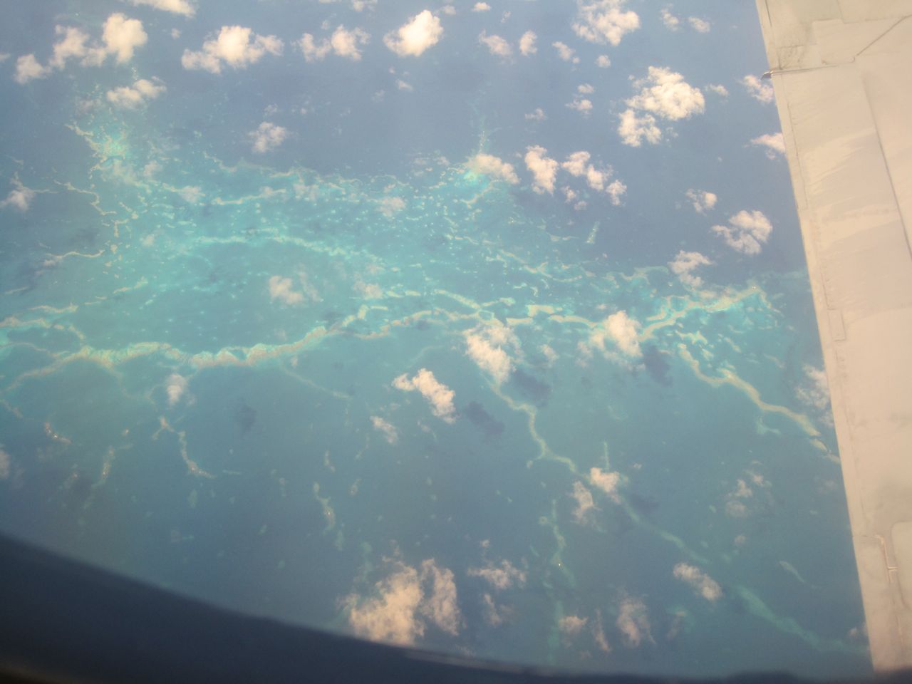
satellite view from PMNM
E komo mai; welcome! Midway Atoll National Wildlife Refuge is surrounded by a lei of foam in the middle of the North Pacific; it's a beautiful, special place.

Not only are there albatross on Midway, but many other interesting kinds of wildlife, both on the land and in the sea. Please enjoy exploring FOAM, an educational blog actively done while on Midway from May through August 2010. Posts are added from off-Midway, as information becomes available. If you're interested in a particular topic, please use the search box or the alphabetical list of "labels" along the left side of the blog page.

Showing posts with label US Fish and Wildlife Service. Show all posts

Monday, August 30, 2010

Final Post -- Aloha, Midway Atoll!


Midway Atoll's Eastern Is. and the emergent reef "lei"
It's the end of August, and my time on Midway has come to an end.  I'm now back home in Waimānalo on the island of O`ahu.  I had a WONDERFUL three months on the Atoll, and my sincere thanks go to the US Fish and Wildlife Service for allowing me to serve as a volunteer.  I had an opportunity to help with many different kinds of wildlife management projects, and I learned a lot.

So, this is my last post, at least for the foreseeable future.  I'd love to volunteer again, especially at a different time of year, to be able to see the albatross, Laysan Ducks, and other wildlife at a different season in their life cycles.  If I do get another volunteer opportunity, I'll certainly re-open FOAM; I've enjoyed creating it very much!

Aloha nui loa, Midway...a hui hou?!
Barb
a few pictures taken from the plane as we flew back to Honolulu--

Pearl and Hermes Atoll

Laysan Atoll
Maro Reef

Sunday, August 15, 2010

"Bracelets" for Red-tailed Tropicbirds

adult Red-tailed Tropicbird
The left-hand picture shows a Red-tailed Tropicbird chick that's grown up and ready to fly away from Midway Atoll to start its own life.  It's at what we call the "fully feathered chick, or FFC" stage.  But before it flies away, the US Fish and Wildlife Service would like to put a "bracelet" on it.

RTTR bands, ready for use
The bracelet is a small metal ring called a "band" with a number.  Each band has a different number; so each bird that gets a band has its own number.  This identifies the bird.  When the FFC grows up, and returns to Midway, we'll know who it is.  If it mates, lays an egg, and raises its own chick, we'll have a record of the family...sort of a "family tree."

Do you see what looks like a large safety pin in the picture, to the right of the metal bands?  That's actually a clip that came off a fishing float, which was found as marine debris on one of Midway's beaches.  We pretended the clip was an RTTR's leg, and learned how to band Tropicbirds.  In this series of pictures, you can see how it's done:


1) A bird band is in the front position in the special, banding pliers.
2) The pliers are squeezed to close the band around the "bird leg."
3) The bird band is rotated.
4) The band is moved to the pliers' back position; the pliers are squeezed...
5) ... closing the band and making it round.
6) The band is on the "bird leg!"

Friday, August 6, 2010

Carbon Dioxide and Global Warming

The dotted black line shows carbon dioxide increasing.
Breathe in; now breathe out.

When you exhale, your breath has more carbon dioxide in it than the air you breathed in.  That's because your body makes carbon dioxide as it burns the food you eat to operate your body.  Carbon dioxide is a waste product.  Your body gets rid of it with each outgoing breath.

Carbon dioxide is building up in the Earth's air.  Although some of it comes from your breathing, most of it comes from the burning of fossil fuels, like gasoline in cars and oil in electric power stations.  Carbon dioxide is the most important gas causing the problem of global warming.

This map shows the places where NOAA collects air samples.  
FOAM's July 25 post entitled "Is the Sea Level Rising?" talked about global warming.  The Earth is predicted to warm to the point where lots of ice in glaciers and ice fields will melt, causing the sea level to rise.  If the sea level rises enough, it could flood coastal cities, like Honolulu, New York, San Franciso, and many others around the world!  We need to stop global warming!  To do that we need to know how much carbon dioxide is in the air.

What does all this have to do with Midway Atoll?  The Atoll is on this map; it's the red dot in the center of the North Pacific Ocean.  Midway is part of a world-wide network to measure how much carbon dioxide is in the Earth's air.  Every week US Fish and Wildlife Biological Technician Greg Schubert takes a sample of Midway's air.  Then he sends it to the federal government agency called NOAA (National Oceanic and Atmospheric Administration) and they measure the carbon dioxide (and methane and other gases) in Midway's air sample.


Greg is setting up the equipment on Midway Atoll.  The air will go in the opening of the white tube at the top of the pole.  Then it will be pumped through both of the blue tanks. 


During collection, Greg is far away because he doesn't want the carbon dioxide he's exhaling to go into the blue tanks.  (The albatross doesn't put out much carbon dioxide!)


When he's done with the field collection, Greg writes down the information, such as pressure and flow rate, in his field notebook.  Later he transfers the information to the official NOAA data sheet that he will mail with the blue tanks.  Midway Atoll National Wildlife Refuge is helping to solve the problem of global warming!

Monday, August 2, 2010

Katie: US Fish and Wildlife Service Volunteer


It was a lot of fun having high school senior Katie on island for a week!  She helped with her mom's Hawaiian Monk Seal beach surveys.  In addition, Katie worked as a volunteer in various wildlife management projects for Midway Atoll National Wildlife Refuge.  She helped:
But perhaps her favorite work was checking on the health of Laysan Ducks (LADU.)
photo by Kittipong Janthasang
For the weekly all-atoll wetlands survey, Katie got very good at using binoculars to see the ducks.  With the binocs, she could often read the code on colored bands that some individual ducks wear on their legs.  [Challenge yourself to read LADU bands in FOAM's "Activity: Laysan Ducks #1 -- Bands" and Activity: Laysan Ducks #2 -- Who's Who!"]  Then Katie entered the data into an Xcel spreadsheet in the Refuge's computer.  Every morning she also helped check each of the wetlands for any ducks affected by the disease, avian botulism.

Each of us needs to help take care of the living things around us.  Katie certainly is a good steward!  How can you volunteer for plants and animals in your community?

Sunday, July 25, 2010

Is the Sea Level Rising?

Our planet Earth is getting warmer, causing the environmental problem we call Global Warming. As Earth warms, the ice fields and glaciers melt, sending water into the oceans, causing the sea level to rise.  How much is the sea level rising?  Let's find out by using advanced laser and computer technology from a plane!  
As with many difficult questions, it takes teamwork to get the answer.  In this case, the team is made up of 2 private companies in Hawai`i and 3 departments of the federal government.  The government team members are: United States Fish and Wildlife Service (USFWS), US Geological Survey (USGS), and National Oceanic and Atmospheric Administration (NOAA.)

The picture above shows the private companies' side of the team, from left to right -- Robert Szabo, owner of Szabo Aerospace from O`ahu, Thomas Pattison, owner of Aerial Surveying, Inc. from Kailua-Kona on the Big Island of Hawai`i,  and his son Kiel.  Rob will fly his plane over Midway Atoll and nearby islands while Tom and Kiel take pictures using a technology called LiDAR.  LiDAR stands for Light Detection and Ranging.  Let's get a look at the equipment while the plane is being fueled.

Kiel is welcoming us aboard Rob's Beechcraft Queen Air plane, nicknamed "Makalani," Hawaiian language for "eyes of the skies."

Inside the plane Kiel shows us the LiDAR equipment.  Tom's company has modified the typical LiDAR rig, which weighs about 150 pounds and would be TOO much weight for the plane.  Next to Kiel's left foot, the 3 silver-colored items are used to send out the laser from the plane.  The laser reflects, or bounces, off the ground, returns to the plane, and that distance between the plane and ground is measured.  Near Kiel's right foot is the black computer.  The computer takes the laser data and calculates how high above sea level Midway's ground is.  The computer also matches up the exact GPS location for each elevation measurement.  And it will be correct to within 6 inches!!

The LiDAR data that Kiel, Tom and Rob are collecting will help answer the question, "Is the Sea Level Rising?"  They can compare the maps they make today with maps from years ago to see how much the sea level has already come up.   In the years ahead LiDAR can be used again to get new data.  Having accurate knowledge about sea level will help all the people on Earth work together to solve the Global Warming problem.

Before we leave the plane, do you notice something blue on the plane's flight deck?  When the hula doll dances, that tells Rob his plane's propeller engines are vibrating too much, and it's time to re-balance them.  The pretty hula dancer has a job to do; she's part of the LiDAR team!

Friday, July 23, 2010

The Albatross are Gone!...but Where?


[On July 28 corrections were made to this post.]
How many Laysan Albatross (LAAL) do you see in this left-hand picture?  Maybe only 5?  Wow, there used to be LOTS in this field...so many that you really couldn't count them!  
The photo on the right shows the same field 2 months ago.  This snapshot appeared in the FOAM post on May 31, "What's Different?"  See!!  There were LOTS of albatross.  Most of them in the field at that time were Laysan Albatross chicks at the black, downy-feathered stage.  Now that it's the end of July, the chicks have grown up and have flown away from Midway Atoll National Wildlife Refuge, their place of birth, or rather "hatch."  Where have all the albatross gone?--where have they flown to?
On a number of posts, I've said that albatross fly off to the North Pacific.  But the North Pacific Ocean is a big place.  US Fish and Wildlife Service scientists asked the question, "Where exactly, in the North Pacific do Midway Atoll albatross go?"

To answer the question, last year scientists chose 4 Laysan Albatross that had hatched on the Atoll.  On July 13, 2009 each albatross was fitted with a small, solar-powered satellite tag.  When these albatross flew away from Midway, tags transmitted the location of each albatross twice each day.  Scientists were able to map that data, or information.  


Here's a map of the North Pacific Ocean from April 4, 2010.  Hawai`i is the string of islands near the center at the bottom of the map, and Midway Atoll is the 2nd island from the left.  Tiny gray circles show where albatross were on different days, and connecting red lines show the flight path.  (I don't know why over half the map is gray.  Perhaps that part of Earth is having night?)

The map has locations for only 2 of the original 4 Laysan Albatross.  The satellite tags on the other 2 birds must have stopped working.  Perhaps feathers covered up the solar panel and the battery couldn't recharge.  Or perhaps when the LAAL took a break from flying and floated on the ocean, the tag stopped working because of the salty water.

But two LAAL had solar satellite tags that did work!  On the west side of the map you can see one albatross was NW of Midway, near Japan.  The east side of the map shows the other albatross NE of Midway, off the coast of California.

Just imagine: Laysan Albatross from tiny, 2-square-mile Midway Atoll migrate to both sides of the North Pacific Ocean!  Of course tracking just two albatross doesn't give scientists enough information to make final conclusions about where albatross spend time in the North Pacific.  Won't it be interesting to see more data?!  

Saturday, July 17, 2010

Is this place a Refuge, a Memorial or a Monument?

It's all three...and more!

(1) REFUGE -- Midway Atoll National Wildlife Refuge
In 1903 President Teddy Roosevelt placed the Atoll under the U.S. Navy's control.  The Navy stopped the poaching of bird feathers and eggs.  Beginning in the 1940's during World War II Midway Atoll was operated as a Naval Air Facility.  In 1998 the Atoll was transferred away from the Navy and became the Midway Atoll National Wildlife Refuge.  The birds were really protected now!  

(2) MEMORIAL --  Battle of Midway National Memorial
On December 7, 1941 Japan attacked the United States at Pearl Harbor in Hawai`i.  The attack caused the U.S. to join World War II against Japan.  Six months later the U.S. fought and won the Battle of Midway.  That victory turned the tide and finally resulted in victory by the United States and its Allies over Japan in 1945.  In 2000 Midway Atoll National Wildlife Refuge was also designated as the Battle of Midway National Memorial.

(3) MONUMENT -- Papahānaumokuākea Marine National Monument
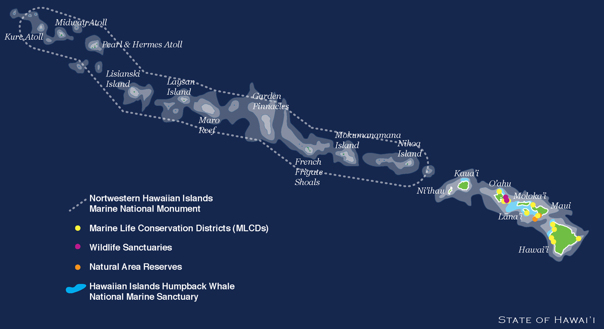
On June 15, 2006 President Bush proclaimed what came to be called the Papahānaumokuākea Marine National Monument.  The Monument map shows that PMNM includes all the islands, including Midway Atoll, stretching northwest beyond the state of Hawai`i.  The PMNM virtual visit says, if the Monument "...were laid atop the continental United States, [it] would cover a distance equal to that between New York City and Omaha, or Boston and the Florida Everglades." Please listen to these mp3 recordings about the Hawaiian meaning and proper Hawaiian pronunciation for Papahānaumokuākea.

(4) World Heritage Center?
As of today, July 17, 2010, we're waiting to hear if the wildlife of Midway Atoll will get even one more level of protection, by becoming a United Nations World Heritage Center.  Stay tuned!
[Update!! -- Read FOAM's July 30th post: "This place is a WORLD HERITAGE SITE!!"]

(5) Pihemanu
FOAM has been calling this land mass "Midway Atoll," but many people think the ancient Hawaiians called it Pihemanu, meaning "the loud din [noise] of birds."  Good name!  Listen to the "pihemanu" in FOAM's July 19th post.

Wednesday, June 23, 2010

Laysan Duck Trans-location to Midway

Laysan Atoll; aerial photo by Andy Collins
Hundreds of years ago we Laysan Ducks probably lived on all the Hawaiian Islands. After people came, we ended up living only on Laysan Atoll, 800 miles northwest of Honolulu. Notice the lake in the middle of the island; it's super-salty!

It's not good for a duck -- or any species -- to live in only one area! A tsunami or hurricane could wipe us Ducks out; we'd go EXTINCT!! To try and save us from extinction, the U.S. Fish and Wildlife Service brought some of us to Midway Atoll National Wildlife Refuge. Having Laysan Ducks in two places helps us survive.

But before the trans-location could take place, in 2004 and '05 USFWS removed the alien-invasive plant Verbesina from some areas on Midway. They used a big vehicle called a backhoe to dig about a dozen large holes in these areas. Freshwater from the surrounding sandy soil slowly seeped into the holes, so we now call these freshwater-filled holes "seeps." Many people helped to plant native Bunch Grass (Kawelu in Hawaiian, Eragrostis variabilis) around the seeps. The document "Examples of Successful Habitat Restoration (pdf)" has lots of pictures showing the creation of Monument Seep on Eastern island.


After the Kawelu had grown and when everything was ready for us, the Service trans-located some of us Ducks from Laysan to Midway Atoll National Wildlife Refuge. I, Kahiko Ladu, wasn't one of the original 2004 or '05 ducks, but my friend was. She came to Midway in 2005, and she now goes by the name "WT," since that's the bird band the biologists put on her right leg. "W" stands for the color of the band, white, and it has a black "T" on it. Barb surveyed Monument Seep today and took this picture of WT. It's a little hard to see, but WT's bill is pinkish; male ducks' bills are darker with a bluish color. (That's a Laysan Albatross chick in the background, and an albatross wing coming in on the right-side of the picture.)

Saturday, May 8, 2010

E komo mai! (Welcome!)

I'm going to Midway Atoll National Wildlife Refuge!!...which is part of the Papahānaumokuākea Marine National Monument, located about 1200 miles northwest of Honolulu, Hawai`i.  From its name you can understand that it's in about the middle of the North Pacific Ocean!  I'll be working as a volunteer there for about 3 months, doing all kinds of wildlife management work.  My friends and I are going to author this blog about Midway together.  Let's introduce ourselves.